Nantucket Places and People:
Tom Never and His Head
by Frances Kartunen
Apostrophes in many island place names have been eroded away by time and inattention. Such is the case of “Tom Nevers.” Now referring to a large out-of-town area once known as the South East Quarter, it once was localized to a high point in the coastal bank known as Tom Never’s Head and a nearby pond, Tom Never’s Pond.
Back in 1775 the Proprietors of the Common and Undivided Land (descendants of the original shareholders in the English settlement of Nantucket) laid out the South East Quarter into shares held by individual members of the proprietary. Between the shares ran roads (some of the earliest “paper roads” on Nantucket) and along the shore the Proprietors mandated a highway reserved “forever for the use of the public” around the headland, past the pond all the way to what is now the entrance to Codfish Park in Siasconset. This was to be maintained in perpetuity for public access “notwithstanding any part of the Bank may hereafter be washed away.”
Even before 1775 the relentless erosion of the shores of Nantucket was a recognized problem. A quarter of a century earlier the town had recorded its anxiety that the sea was washing away parts of the island. At one time the beach between Tom Never’s Pond and the ocean was so narrow that waves often washed over into the pond. Then, in the latter half of the 1800s, the eastern shore accreted rapidly. Up at Codfish Park, the land set aside as the Siasconset Bathing Beach Trust grew from its original 11.5 acres to 25 acres before suffering erosion once again in the 1990s. A considerable stretch of beach still separates Tom Never’s Pond from the sea, but Tom Never’s Head has been severely sheared off by the sea since the 1960s, and the process is ongoing.
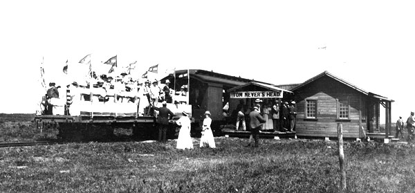
This photograph c.1900s shows the Tom Never’s depot with its sign board (complete with apostrophe) and a crowd waiting for the train, with the Tom Never’s auction alongside.
PHOTO REPRINTED COURTESY OF NANTUCKET HISTORICAL ASSOCIATION
In 1881, a railroad line was built from Steamboat Wharf in town to the south shore at Surfside, and in 1884 it was extended to Siasconset. Apparently no heed was taken of the encroaching sea when the roadbed was laid out. In the run from Tom Never’s Head up to Siasconset, it ran on an embankment that passed between the pond and the ocean. Parts of the embankment are still there today, but storm winds and waves took out major sections of the track, at one point stranding the engine Dionis and her cars in Siasconset with no way to return to town. The Surfside Hotel was abandoned and collapsed in a storm. A new roadbed was laid out from town to Siasconset, but it, too, ran below the bank from Tom Never’s Pond to the station at Codfish Park.
While the Surfside development scheme deflated and Siasconset boomed, the old South East Quarter lay dormant, gradually being overgrown with scrub oak. Its only potential attraction was the ocean view from Tom Never’s Head. In 1916 a pair of land speculators from off-island decided to give it a try. They purchased land stretching from two miles frontage on the Milestone Road to two miles of shorefront, diagonally bisected by the railroad. One of the first buildings that went up was a railroad depot with a sign reading “Tom Never’s Head.” (Tom still had his apostrophe at this point.) Next a large lodge went up with a viewing tower from which potential purchasers of house lots could survey the land. Absolutely nothing came of this enterprise. No one could be induced to buy a piece of land and build a house on it. After a couple of seasons operating as a restaurant, the lodge was abandoned, and in the early hours of August 26, 1938, the derelict building burned to the ground.
So who was Tom Never, whose name was appropriated for this ill-fated land speculation? The Nantucket Wampanoag Never family—with their surname variously spelled Never, Nevar, and Neaver—is documented through account books, court records, and vital statistics of the town of Nantucket. Jonas Never appears in Mary Starbuck’s account book in the mid 1680s. “Old Never” (his baptismal name may have been Jonathan) is listed as one of the Wampanoag “masters of families” in 1723. Six members of the Never family—two men, two women, and two children—perished in the devastating “Indian Sickness” that struck Nantucket’s Wampanoags in the winter of 1763-64. But Tom Never? No record of him is to be found, unless perhaps he is “Old Tom,” who had an account with Mary Starbuck in 1685.
But the developers didn’t just make up the name in 1916 to lend cachet to their scheme. On Ferdinand C. Ewer’s 1869 map one finds Tom Never’s Head, Tom Never’s Pond, and also Tom Never’s Swamp, all tucked into the elbow of the South East Quarter. Ewer knew his Wampanoag places and place names. If only we could ask him about Tom Never.
According to William Root Bliss, an author of September Days on Nantucket, published in 1902, Tom Never was an Indian whom the English settlers put in charge of a whale look-out station at the southeast corner of the island.
Tom Never’s Head was eventually developed, first as a military installation, then as a Veterans of Foreign Wars post and a recreational area, and finally today as the residential area that the 1916 would-be developers futilely bet their money on. Perhaps the most universally appreciated island-wide event that takes place at Tom Never’s Head these days is the annual Island Fair each September.
Frances Karttunen’s books, The Other Islanders: People Who Pulled Nantucket’s Oars and Law and Disorder in Old Nantucket are available at Nantucket bookstores.