Mapping the Middle Moors
by Frances Karttunen
After turning right off Polpis Road and heading into the Middle Moors, about half way to Altar Rock there is a chance to turn right again on a road that heads back toward the town of Nantucket. Roughly paralleling Polpis Road, this unpaved road skirts Taupawsha’s Swamp before devolving into an overgrown bridle path. Scattered along both sides of the road are several lovely little kettle-hole ponds. Around them high-bush blueberries ripen in late July, and at water’s edge can be found tiny insect-eating sundews. In autumn the bright blue eyes of the scattered ponds punctuate a patchwork of bright red blueberry leaves, soft green bayberry, rusty scrub oak, and purplish grasses—a sight that is best appreciated from the air on approach to or departure from the Nantucket airport.
These ponds were created at the end of the last ice age by chunks of glacial ice melting away into the ground. The bottoms of the resulting depressions impinge upon Nantucket’s current water table, so seeping ground water keeps the ponds more or less full. Their fluctuating water levels have been an object of fascination for countless generations of island residents.
At the end of the nineteenth century and through the first half of the twentieth, the landscape around the ponds was almost free of brush. This openness was the legacy of sheep grazing the moors for a couple of centuries. Since then, scrub oak has gradually encroached on the ponds, making access to their shores a bit more difficult.
For most of the twentieth century Nantucketers called them the Foot Ponds. Previously they were called the Poot Ponds, while nowadays one hears them called the Pout Ponds. Each spelling has its story. For people who have heard them called “Foot Ponds,” they resemble water-filled footprints left by a giant stomping across the swampy ground.
Quite a different story has been attached to the “Poot Ponds,” however. “Poot” is the Wampanoag word for “whale,” and back on February 28, 1829, the Nantucket Inquirer printed a putative Indian legend about whales taking shortcuts between Nantucket Sound and the Atlantic Ocean by swimming directly under the island. In this story, each little Poot Pond offered a place for whales to surface, spout, and breathe. The contributor of the story to the newspaper said he had received it from his great-grandfather, putting its origin back to the days when Wampanoags were still a living presence on Nantucket.
Why have people started to call them the “Pout Ponds”? This pronunciation goes back to spelling on the Rev. Ferdinand C. Ewer’s 1869 map of Nantucket.
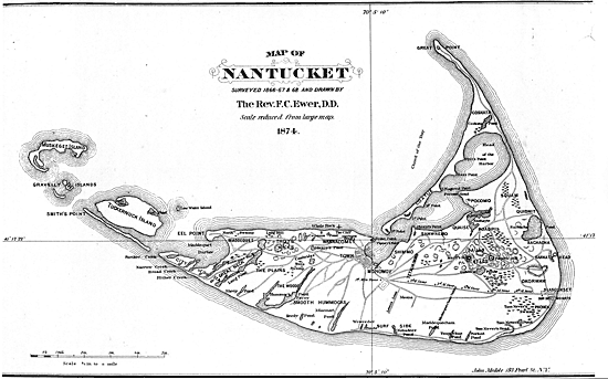
Dr. Ewer's Map, courtesy of Nantucket Historical Association.
Ewer was a clergyman by vocation but an avid geologist by avocation. In the years after the Civil War, he tramped over every inch of Nantucket, trying to understand its glacial history. In 1869 he published a map that has gone through many a reprinting in years since. Once it was Nantucket’s most accurate and detailed map, a worthy successor to William Mitchell’s 1838 map of the island. Today it is a nostalgia piece, a reminder of days gone by before erosion altered Nantucket’s shores.
Particularly striking on Ewer’s map is the long spit of land extending westward from Madaket. Up through the summer of 1869 it was still possible to drive a horse and wagon from Nantucket Island to Tuckernuck Island by following this spit out to its end and then fording some shallow water. The last person to do so was a man named Isaac Folger, who made the trip before a September storm of that year created a dangerous breach known as “the opening.” The spit has long since disappeared, and currently new developments are taking place in those waters, with sandy little islands beginning to emerge from shoals.
Erosion along the South Shore has pushed the beach back so far that Nanahuma’s Neck has connected with it, dividing off Clark’s Cove from Hummock Pond. The Forked Ponds and Little Mioxes Pond are gone, and only a vestige of Weeweder Pond remains. In town Micah’s Pond, located near the west end of India Street, is utterly lost. Only on Ewer’s map do these still live on as once they were.
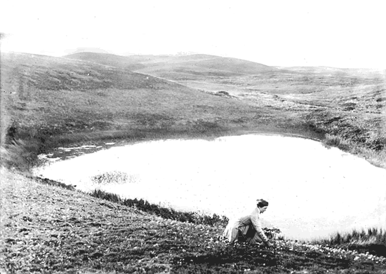
Pout Pond, courtesy of the Nantucket Historical Association.
Ewer’s map has inspired any number of people to tramp the island as he did in order to check its accuracy. As Ewer himself predicted, it has been found to be a bit off in its details. Nonetheless, he packed into it a vast amount of information, including many place names that would otherwise have been forgotten long ago were it not for the ubiquitous presence of his map on walls of Nantucket’s public places reminding us of those names and places.
That ubiquity makes the Ewer map more of an unimpeachable authority than it perhaps should be. If one finds Miacomet Pond on the map, one sees that it is written “Miacomet.” But if one looks up at Ewer’s timeline, under the year 1673 one sees the spelling “Hyacomet.” For the same year we see the spelling “Sherborne,” for the English town, while under the year 1795 it is spelled “Sherburne.” Inspection can probably turn up other variations that may have been quite unintentional on the part of Rev. Ewer. And so we come to “Pout Ponds.” Where “Pout” is printed, Ewer probably intended “Poot.” Enshrined on the map, “Pout” has lately spread to other maps, become the name of a road, and given rise to a pronunciation Ewer would probably not have recognized.
With a new pronunciation, can a new legend be far behind? What is there about these little ponds that could make a person pout? Perhaps there should be a contest.
The Nantucket Conservation Foundation’s Middle Moors Properties Map is a guide to the whole area and shows how to get from Altar Rock Road to the ponds via Pout Pond Road. A search in the Nantucket Historical Association’s online historic images database will lead to an old edition of Ewer’s map and two images of one of the Poot Ponds taken nearly a century apart. One is late-nineteenth-century photograph showing a woman at the edge of the pond. The moors spreading out in all directions are notably devoid of brush.
Frances Karttunen’s books, The Other Islanders: People Who Pulled Nantucket’s Oars, Law and Disorder in Old Nantucket, and People and Places vols. 1, 2, and 3 are available at Nantucket bookstores.