The Oil Spill
by Dr. Sarah D. Oktay
Managing Director UMass Boston Nantucket Field Station
I had planned to write about a more innocuous subject this week; there are many that intrigue me, from squid to bamboo. But I can’t seem to shake the constant reminder that while we begin to enjoy a warm and pollutant free summer, the states bordering the Gulf coast are dealing with an oil spill of epic proportions. On April 20, the British Petroleum (BP)/Transocean Ltd. drilling rig the Deepwater Horizon exploded at a depth of 5000 feet, taking 11 lives and setting off the largest man-made environmental disaster to hit U.S. waters.
Whether any detectable remnant oil reaches our shores can be debated, but the effects of this spill will be felt across the country and on Nantucket long after we have grown old. Reputable and very conservative estimates put the total oil volume spewed from the well as much greater than that released by the Exxon-Valdez, which leaked an estimated 257,000 barrels (nearly 11 million gallons) of oil into Prince William Sound in 1989. Early BP estimates put the Deepwater Horizon spill at 5000 barrels a day (1 barrel equals 42 gallons) but that number has been revised upwards to a value of 19,000 barrels a day as of early June. That is equivalent to a starting point of 210,000 gallons to close to 798,000 gallons of oil escaping from the well for a total estimate of 18-39 million gallons (428,000-929,000 barrels). As of June 6, oil had reached Louisiana, Mississippi, Alabama, and Florida shores. Believe it or not, the Deepwater Horizon spill is not the biggest ever in the Gulf of Mexico. In 1979, a two mile deep exploratory drilling rig in Mexican waters, the Ixtoc I, blew up, releasing 140 million gallons of oil. It took nine months to cap that well and experts called in to help included the legendary Red Adair (www.incidentnews.gov/incident/6250).
As a born and bred Okie, I come from an oil background; my father worked for Philips Petroleum as a chemical engineer for many years and my uncle was a geologist at Phillips. Oil derrick pumps are a normal part of the landscape to me. Later in life after my father passed away, my mother married a Sunoco Oil employee, which was a traumatic turn of events for the Philips 66 side of the family. While I was down in Galveston going to college for ten years, we’d look out each night onto a horizon flecked with the lights of fantastically large rigs and ocean cruises on research vessels included sailing by these offshore cities. Many of my fellow students from the Texas A&M University in Galveston Marine School are scattered across the globe working for oil research and development divisions in companies such as Schlumberger and Halliburton.
Oceanographers around the country gathered last week at an emergency science symposium held at the Louisiana State University in Baton Rouge. Of greatest concern is the depth of the spill; traditional techniques that work on land or on oil spill on the surface are not nearly as effective at depth. And according to a growing number of sources (summary can be found at www.newsweek.com/2010/06/06/what-the-spill-will-kill.html), a large plume is moving east of the leak, reducing oxygen levels, most likely adversely impacting marine biota, and staying out of the reach of containment technology. Evidence of a deep water plume extending east of the spill site was measured by scientists aboard the R/V (Research Vessel) Pelican which I have been on several times during my career. It recently was retrofitted and upgraded, but my first thought was, wow, that is almost as fun as doing research off the African Queen. The R/V Pelican was built in 1985 as an oceanographic research vessel and is operated by the Louisiana Universities Marine Consortium (LUMCON). The vessel has four laboratories and can support 16 scientists for periods up to three weeks. In May 2010, it was one of the first scientific vessels to arrive at the site of the Deepwater Horizon oil spill in the Gulf of Mexico to begin the process of characterizing the extent and consequences of the spill. In the largest spill recorded in the Gulf of Mexico (GOM) mentioned above (the Ixtoc I), it is estimated that 25 percent of the escaping oil sank to the bottom of the Gulf. According to the Newsweek article cited above: “As far as scientists can tell, the undersea oil is actually a witch’s brew of crude mixed with dissolved methane, stretching 15 miles long, 5 miles wide, and 300 feet thick in the case of one plume detected by the Pelican, and 22 miles long, 6 miles wide, and 3,000 feet thick in the case of a plume found by University of South Florida researchers aboard the WeatherBird II last week.”
These plumes, although not easy to detect with the naked eye, they can be detected chemically, are of highest concern to scientists for a variety of reasons: the entire food web is based on phytoplankton that live throughout the water column and are susceptible to minute chemical changes; marine mammals cannot easily detect these anomalies in the water and will swim through them; material that sinks to the ocean floor will hurt everything from coral reefs like the Gulf’s Flower Gardens to exotic deep sea seep communities; and larger planktonic (free floating) animals like jellyfish who provide sustenance for sea turtles and other marine creatures are especially vulnerable to the spill effects.
One advantage for area scientists studying new energy sources is a nearby study site about nine miles from the oil spill source that is the home of the Gulf of Mexico Consortium’s Methane Hydrate Seafloor Observatory. In the seven years of the observatory’s development, scientists have collected a wealth of geologic, physical, chemical, and biological data describing the area—data that could be important in measuring changes there that stem from the oil spill. NOAA is now diverting ongoing science mission teams like researchers from the National Institute for Undersea Science and Technology (NIUST) from their original tasks of investigating coral reefs to instead have them obtain core sediment samples from the seafloor and water samples from the water column in areas near the Deepwater Horizon spill source (from www.noaanews.noaa.gov/stories2010/20100506_spillsampling.html).
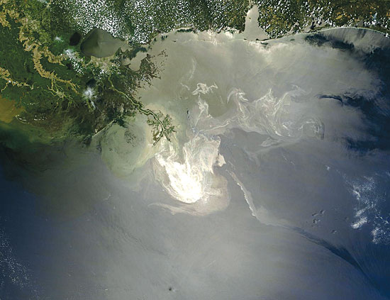
The picture above shows the surface extent of the spill on May 24 off the coast of Louisiana. And there are now about 12 underwater ROV (remotely operated vehicle) cameras still functioning at the site which can be accessed via BP home page by clicking through to “response in video” at www.bp.com/genericarticle.do?categoryId=9033572&contentId=7062605. Sadly, many of the GOM oceanographic buoys which could be used to track the spill have gone offline in the past few years due to decreasing funding (rucool.marine.rutgers.edu/deepwater/2010/06/federal-funding-cuts-leave-oceanographers-spill-responders-in-dark/). Here at the UMass Boston Field Station on Nantucket, I have not yet been able to deploy the streaming data buoys I normally install in both harbors, so I can feel their pain.
The impact to species in the GOM has been immediate and concerning. Sea turtles are washing up on the shores of MS, LA, and neighboring states at an alarming rate. Within the first three weeks of the spill 23 sea turtles washed up. Normally 1-2 might. Close to 400 miles of beaches are already affected, and tar balls are washing up in Pensacola. A species that has just recently bounced back from near extinction, the brown pelican, is being hit hard. According to the June 6 online issue of the LA Times Environment section (latimesblogs.latimes.com/greenspace/2010/06/gulf-oil-spill-wildlife-toll-grows-as-oil-seeps-in.html): “The number of birds found alive and coated in oil throughout in five Gulf Coast states has nearly doubled to 177, with 156 of them picked up in Louisiana. But 547 birds have been found dead, 73 of them oil-soaked. It is not known whether the others died as a result of the oil, but experts said that's possible.” The National Oceanic and Atmospheric Administration has closed more than a third of federal waters to fishing with the greatest effects so far in Louisiana and Mississippi.. Texas fishermen should be able to harvest brown shrimp when their season opens on July 15 and come November 1, they may still have a very viable, and profitable, oyster harvest, but they will be absorbing fishermen from all the other Gulf States.
According to the today’s early online edition of the Business Standard, who compares the spill to both the Exxon-Valdez and the Three mile Island disasters (www.business-standard.com/india/news/analysis-gulf-spill-trickier-than-valdez-three-mile-island/96764/on), the primary long term effect will be to push oil exploration out of U.S. waters and into foreign oil fields, furthering our dependence on sources outside of the U.S. Oil rig safety and regulations regarding deployment and backup devices for rigs will most likely improve as the call for a greater reliance on alternative energy sources grows. But even the most ambitious plans for alternative fuels will take years to fully develop. The irony for many people in the Gulf coast is that this may be a 1-2 punch, those who don’t work as fishermen tend to be employed by the oil and energy companies.
A series of approaches to cap or plug the well and contain the spill have failed, with the latest one, a containment dome or cap funneling oil into a surface vessel finally showing promise. That vessel, the Discoverer Enterprise drill ship, can only handle 15,000 barrels a day and it is already capturing 10,000-15,000 gallons of oil from the well per day, so BP has had to leave some of the vents open on the well. At a depth of 5000 feet, the cold and pressure of the sea can also cause methane hydrates (frozen methane) to form, which has stymied some of the earlier recovery attempts. Crews will continue to drill two relief wells, considered the only surefire way to stop the leak, with completion of those wells expected in August at the latest. According to the June 7 online edition of the New York Times, the Coast Guard estimates that the clean up efforts will last into the fall.
Tar balls washing up as far south as the Florida Keys in mid May have been determined to not be coming from the Deepwater horizon oil spill which is a small consolation. Unfortunately, before new regulations prohibited the dumping of materials from boats, tar balls were a pretty common occurrence on Gulf state beaches, and they littered the shores of Galveston in 1990.
I still have doubts as to whether a significant concentration of oil can make it up here to affect our shoreline; what IS important is that fish, marine mammals, and bird species all travel, some very long distances; so several species may experience dips in their populations due to impacts down south. For instance, blue fin tuna use two primary breeding grounds, the Gulf of Mexico and the Mediterranean. They are relatively protected from small scale surface oil spills, but the deepwater plumes can easily infiltrate their prey species with toxic levels of oil, dispersants, and breakdown products. (The hazards of dispersants are significant and too involved to discuss in this article, but they too pose a significant long term risk almost worse than the oil). Atlantic fisheries are all connected (think stripers and cod), so the spill may make it far enough up the Atlantic coast to effect some fisheries species. Most of the oil, if successfully transported via the Loop current in the Gulf and around the Florida coast to be entrained into the Gulf Stream; would make it perhaps as far as the Carolinas and mid Atlantic states before it started across the Atlantic (http://findanswers.noaa.gov/noaa.answers/consumer/kbdetail.asp?kbid=554). The most recent loop current and oil transport models and maps can be seen here for the ultimate ocean geeks out there: http://radiofreekeywest.com/blog/?p=1033.
I guess in an eternally optimistic world that even I don’t live in, the spill will provide new information on ocean current volumes, speeds, and directions. Scientists’ will be looking for remnants of the spill and for tell-tale chemical signatures in creatures, water, and sediment downstream of the event for many years to come. Locally, our Nantucket and Madaket Harbors Action Plan (Final update - 2009; http://www.nantucketharborplan.com/) has an entire section devoted to oil spill control and harbor security and projection measures have been in place for many years on our docks and piers. We are ahead of the game in our ability to handle spills and even tiny spills are quickly cleaned up by the Marine and Coastal Resources Department and individual boat owners with oil spill treatment packages located on the docks where spills might occur. Action items in the Harbor Plan include outfitting land based storm drains that eventually feed into the harbor with quickly deployable covers to prevent oil spills from reaching the water.
The impacts to the northeast may be most evident economically, in regulations, and in the speed in which alternative energy projects like wind are implemented. Deep water oil exploration will likely continue, hopefully with much more effective safeguards for employees and our environment. Hopefully we can reduce or eliminate the occurrence of another deepwater spill. For more information and as a sign that we are firmly entrenched in the digital age; the Wikipedia entry on the Gulf Oil spill is one of the longest I have seen. Access it at en.wikipedia.org/wiki/Deepwater_Horizon_oil_spill.